Hazard Map
When sightseeing, it is very important to gather disaster prevention information, such as what kind of disaster risk there is in the places you visit in order to protect yourself from disasters. In Kamakura City, we have released the “Kamakura City Disaster Prevention Information Map (Kamakura Wagamachi Map),” which discloses disaster hazard information using a GIS system, as well as “various hazard maps.”
Easy Hazard Map
This hazard map is designed to be easy to read, and is created by dividing Kamakura City into six parts.
It is an expression that is easy for children to understand.
With Easy Hazard Map, you can check the hazard risks of tsunamis, storm surges, floods, and landslides on a single map.
Maps of each map area
-1.jpg)
Maps
- Easy Hazard Map ①,④ (PDF: 3,080KB)
- Easy Hazard Map ①,② (PDF: 3,653KB)
- Easy Hazard Map ②,③,⑤ (PDF: 3,218KB)
- Easy Hazard Map ④,⑥ (PDF: 3,534KB)
- Easy Hazard Map ⑤,⑦ (PDF: 3,867KB)
- Easy Hazard Map ③,⑤,⑧ (PDF: 3,460KB)
Enlightenment
- Easy Hazard Map Awareness Zone ①,④ (PDF: 3,966KB)
- Easy Hazard Map Awareness Zone ①,② (PDF: 3,965KB)
- Easy Hazard Map Awareness Zone ②,③,⑤ (PDF: 3,954KB)
- Easy Hazard Map Awareness Zone ④,⑥ (PDF: 3,963KB)
- Easy Hazard Map Awareness Zone ⑤,⑦ (PDF: 3,960KB)
- Easy Hazard Map Awareness Zone ③,⑤,⑧ (PDF: 3,960KB)
Kamakura Wagamachi Map
The Kamakura City Disaster Prevention Information Map (Kamakura Wagamachi Map) is a system that allows users to individually select and display disaster hazard information due to “tsunami”, “earthquake”,“flood”,“inland flood”, and “landslide”, as well as location information of evacuation centers and public facilities on the Internet cloud, using GIS (Geographic Information System) on the Internet cloud to raise citizens’ awareness of disaster prevention and to consider appropriate evacuation actions in the event of a disaster.
- Kamakura City Disaster Prevention Information Map (Kamakura Wagamachi Map) for PC (External link)
- Kamakura City Disaster Prevention Information Map (Kamakura Wagamachi Map) / for smartphones and tablets (External link)
Various Hazard Maps
Hazard maps are available on the Kamakura City official website.
Link to: https://www.city.kamakura.kanagawa.jp/sougoubousai/hazardmap.html
Shelter
In order to ensure the safety of citizens in the event of a disaster or the threat of a disaster, Kamakura City will open evacuation centers as necessary. Since the opening status varies depending on the damage, the opening status will be announced via the Disaster Prevention and Administration Radio, the Kamakura City Hall website, and the evacuation center opening and congestion status distribution service “VACAN”.
In the event of an earthquake disaster
When an earthquake of seismic intensity 5 or higher is observed in the city or adjacent Fujisawa City, Zushi City, or Sakae, Kanazawa, or Totsuka wards of Yokohama City, municipal elementary and junior high schools will automatically be opened as evacuation centers. Temporary accommodation facilities will also be opened, if necessary, for tourists and other people who have difficulty returning home.
In the event of wind and flood damage
Evacuation centers opened in the event of wind and flood damage such as typhoons and heavy rains will be opened as necessary at municipal elementary schools and branch offices depending on the situation of the disaster.
Temporary accommodation facilities (for those who are unable to return home)
This is a facility where people who have difficulty returning home from an outing due to a disaster can stay temporarily, and will be opened depending on the situation.
Kamakura area
| Hasedera Temple | 3-11-2 Hase,Kamakura |
| Tsurugaoka Hachimangu Shrine | 2-1-31 Yukinoshita,Kamakura |
| Kamakura Lifelong Learning Center | 1-10-5 Komachi,Kamakura |
| Kamakuragu Shrine | 154 Nikaido,Kamakura |
| Ankokuronji Temple | 4-4-18 Omachi,Kamakura |
Fukasawa area
| Kamakura Budokan | 616-6 Yamasaki,Kamakura |
Kitakamakura area
| Kenchoji Temple | 8 Yamanouchi,Kamakura |
| Engakuji Temple | 409 Yamanouchi,Kamakura |
Ofuna area
| Kamakura Art Museum | 6-1-2 Ofuna,Kamakura |
Opening of evacuation centers and checking the congestion status
You can check the congestion status of the evacuation center with your smartphone or other device
When the city opens an evacuation center in the event of a disaster, it is possible to check the location and congestion status of the evacuation center using a smartphone or computer using the “VACAN” service for opening and distributing the congestion status of the evacuation center.
“VACAN” can also be checked by those who live outside the city. If you don’t have a smartphone or computer, or if you’re not good at handling it, you can check with a family member or acquaintance who lives far away and share it.
The congestion status of evacuation centers is displayed on four levels: “vacant”, “moderately crowded”, “crowded”, and “full”.
How it works
You can use it from the link below or from the QR code.

It is a good idea to prepare the following items in your bag or backpack in case a disaster occurs during sightseeing.
In a richly natural sightseeing area such as Kamakura, it is a good idea to be prepared for risks such as sudden earthquakes and heavy rain in case of emergencies.
Things to bring when sightseeing in Kamakura
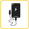
Mobile battery
For disasters, a large battery capacity is recommended.
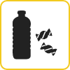
Drinking water and portable food
A sports drink to help prevent dehydration is also a good idea!

Folding umbrella
It can protect your physical strength from rain, wind and strong sunlight.

Paper maps such as tourist maps
It is a good idea to have a paper map so you don’t run down the charge of your phone!

Contact information of your reserved accommodation
It’s a good idea to write it down.

My Number card
In case of illness or injury

Regular medications and hygiene products such as masks
Prepare more in case of disaster.

Cash
In case cashless is not available.
Useful Links for Disaster Prevention
Click here for a list of useful links for disaster prevention
Links – “BOSAI” Kamakaura
Safety tips for travelers
“Safety tips” is an app developed under the supervision of the Japan Tourism Agency that notifies you of disaster information in Japan.
This app was developed under the supervision of the Japan Tourism Agency and is a free app that notifies you of earthquake early warnings, tsunami warnings, eruption warnings, weather warnings, typhoon information, heat stroke information, civil protection information, evacuation information, etc. in Japan.
For foreign tourists visiting Japan, there are various functions that are useful in the event of a disaster.
It is available in 14 languages (15 languages): Japanese, English, Chinese (traditional and simplified), Korean, Spanish, Portuguese, Vietnamese, Thai, Indonesian, Tagalog, Nepali, Khmer, Burmese, and Mongolian. It is recommended to download it in advance.
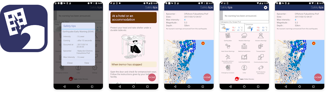
Safety tips for travelers : https://www.jnto.go.jp/safety-tips/eng/app.html
Emergency contact information
Disaster prevention and safety information e-mail distribution service
Kamakura City provides a service that delivers information on disaster prevention, such as weather information, and safety and security information, such as information on suspicious persons, to cell phones and PCs via e-mail in Japanese.
All you need to register is your email address, and you don’t need to register your name or address. If you would like to receive e-mails, please register from the URL below.
https://www.city.kamakura.kanagawa.jp/sougoubousai/haishin0001.html (Japanese language support only)

Hazard Map
Various hazard maps published by Kamakura City.
hazard map
Support Station for people who are unable to return home
https://www.pref.kanagawa.jp/docs/j8g/bousai/documents/kitakustation.html
Links ― Helpful Apps and Websites in the Event of Disaster
Government Agencies
Private Institutions
In case of emergency, we will provide emergency contact information so that tourists can respond quickly. In the event of an emergency, please contact the appropriate contact point according to the situation.
Kamakura City
Kamakura City Official Website
TEL: 0467-23-3000 (representative)
Hours :8:30 am – 5:00 pm on weekdays (Closed from December 29 to January 3) .
Police Station, Fire Station, Public Transportation
The main contact points are as follows:
[Police and Fire Stations]
Kamakura Police Station:0467-23-0110
Kamakura Fire Station:0467-25-7524
[Railway]
JR Kamakura Sta., Kita-Kamakura Sta., Ofuna Sta.: JR East Japan Inquiry Center 050-2016-1600 (6:00-24:00)
Enoden Kamakura Sta.: 0467-22-2101
Enoden Hase Sta.: 0467-22-1782
Shonan Monorail Ofuna Sta.: 0467-45-0135
[Bus]
Enoden Bus Kamakura Office: 0467-46-5191
Keihin Kyuko Bus Kamakura Office: 0467-23-2553
[Taxi]
Keikyu Kotsu : 0467-44-2214
KG Group : 0467-31-0101(Same-day vehicle dispatch) /0467-31-0606(Cars will be dispatched at a later date.)
Kamakura Smile Taxi: 0467-40-5396
Royal Kotsu: 0467-43-1245
Ofuna Jidosha: 0120-46-2047
Hospitals in Kamakura
For more information on the emergency medical care system in Kamakura City, please refer to the “Emergency Medical System in Kamakura City” section of the Kamakura City website.
Earthquakes
Kamakura City is located in the southern Kanto region, and is expected to be damaged by various earthquakes, such as the Nankai Trough Earthquake and the Tokyo Metropolitan Earthquake (Earthquake directly under the southern part of Tokyo, Taisho Kanto Earthquake, etc.). In particular, there are concerns about damage caused by tsunamis


Useful Links for Disaster Prevention
Click here for a list of useful links for disaster prevention
Links – “BOSAI” Kmakaura
Tsunami
Coast area is particularly at higt risk of Tsunami.

Typhoon
As Kamakura is located by the sea, it is considered vulnerable to high waves and tides and storms during typhoons. Please consider the option of refraining from sightseeing when a typhoon is expected to approach.
Storm and Flood Damage
Intensive heavy rainfall can cause river flooding and urban flooding.
Sediment Disasters
Since it is surrounded by mountains on three sides, there are areas that are prone to landslides and cliff slides due to heavy rains. Please note that there are many places designated as “Sediment Disaster Alert Areas” and “Sediment Disaster Special Alert Areas”